|
Current Projects:
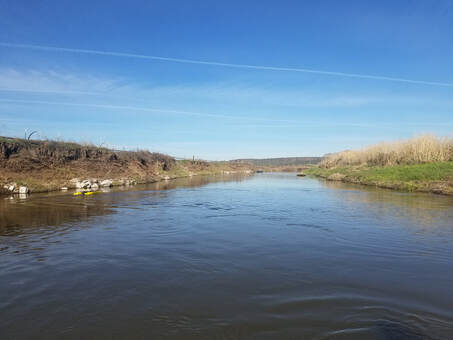
Lower Crooked River Strategic Restoration (RCPP) Lower Crooked River Strategic Restoration (LCRSR) is a comprehensive project intended to address degraded fish and wildlife habitat, water quality, and riparian plant communities over 17 miles of the Crooked River in Central Oregon. Proposed restoration activities include both instream and riparian restoration to improve habitat for fish and wildlife, water quality, and agricultural productivity. In addition, the project will reduce the threat of regulatory enforcement associated with the Federal Endangered Species Act and compliance with non-point source impacts from agriculture under Sections 303 and 319 of the Federal Clean Water Act. The project area is within the Lower Crooked River watershed on the mainstem Crooked River from approximately river miles 30-47. The project area is ~6,200 acres, with the boundaries being State Highways to the east and south, a county road to the west. The north boundary is partially set by a county road and partially by the topographic change from existing basalt ridgelines which create a sharp break from irrigated agriculture to a more upland landscape. The project area is a major focus for the reintroduction of anadromous fish to the Upper Deschutes Basin above the Pelton-Round Butte hydroelectric complex on the mainstem Deschutes River. Since the beginning of the reintroduction effort in 2007, juvenile smolts from the Crooked River have been the most successful and over 95 percent of returning steelhead have returned to the Crooked River. There has been a consistent increase in the number of returning adult steelhead, and the first spawning since the 1960s was documented in 2015 in McKay Creek within the project area. In addition, Chinook salmon returns have been slowly increasing. This project will leverage the impact of the completed and remaining fish passage activities to increase the ecological benefits and vastly improve the habitat potential for anadromous fish in the Lower Crooked River. |
|
|
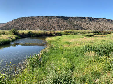
Foley Butte Holistic Restoration:
Foley Butte Ranch, located in the northwest corner of Crook County, Oregon, encompasses 30,655 acres of timberland, creeks, meadows, and mountains. Working on a large property of this size offers a unique chance for large scale watershed restoration work throughout the uplands, and several different headwaters of tributaries to McKay creek. This project tackles several limiting factors identified in this area by working with partners to address habitat needs on a holistic landscape scale. Project elements include cutting junipers, protecting aspen stands, developing springs for water, weed treatments and riparian restoration. |
|
|
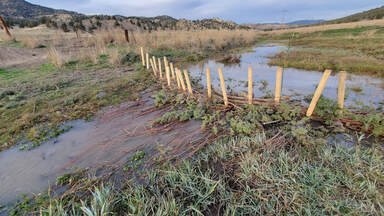
Horse Heaven Creek BDAs:
Horse Heaven Creek BDA project is located on a ranch in Post, Oregon. Working together with the property Landowner, the USDA/CREP Program Technician, Crooked River Watershed Council, Western Beavers Cooperative and USF&WS, the project objectives are to restore prioritized “BeaverHOOD” reaches – an approach providing the conditions beavers need to succeed in establishing home base reaches and actively manage the floodplains that this project would help to create. Tasks include BDA building on 3.2 miles of Horse Heaven creek and riparian planting and protecting. |
|
|
Past Projects:
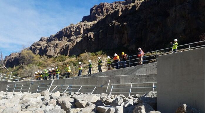
Opal Springs Opal Springs is a hydro dam project located at mile 7.2 on the Crooked River. The Opal Springs project broke ground in May of 2018 and was completed in November 2019. The project goal was to address a fish barrier by constructing a fish ladder and providing full passage to fish species seeking the Crooked River. The first documented steelhead to successfully pass through the new ladder was detected a mere 72 hours after the ladder was fully operational. This project was completed on schedule and budget and has allowed for thousands of fish to pass. |
|
CONTACT US
Tel: 541-447-8567
[email protected]
Crooked River Watershed Council
498 SE Lynn Blvd.
Prineville, OR 97754
Tel: 541-447-8567
[email protected]
Crooked River Watershed Council
498 SE Lynn Blvd.
Prineville, OR 97754